API

Posted

Mon Mar 3 2014, 3:15pm

By Kristina Weis

Categories

API
News

Esri Geotrigger Service Launches – What Geoloqi Customers Should Know

We’ve recently launched Esri’s Geotrigger Service, which is the new and improved version of Geoloqi’s technology.

The original Geoloqi service will be retired on August 19, 2015 (18 months from the time the Esri Geotrigger Service launched). We encourage current Geoloqi customers to migrate to Esri’s Geotrigger Service soon to take advantage of all the improvements.

Why use the new Geotrigger Service?

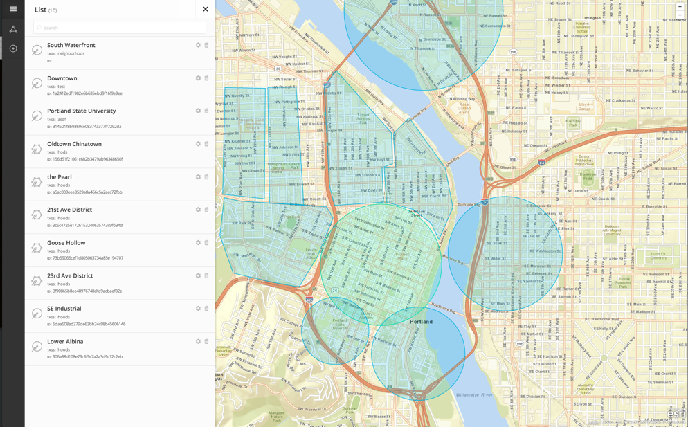
Geoloqi is now part of Esri, based in Esri’s R&D Center in Portland, Oregon. Most of our time and energy this past year went into improving our Geotrigger Service, which provides better GPS accuracy, ease of use, longer battery life, and attractive pricing. We also added the ability to create complex polygon triggers, and we built the Geotrigger Faker, which is a graphical tool that allows you to simulate the location of fake or real devices in order to better test and debug your app.

What about pricing?

The Geotrigger Service is one of the many features offered through ArcGIS. You can start a 30-day free trial right away. Subscriptions begin at $20 per month and you get 2,400 Geotrigger events per month. This represents a significant price improvement over the Geoloqi plans, as the new Esri plans offer three times the number of Geotrigger events.

Can I get help migrating?

If you haven’t migrated to the Esri Geotrigger Service by the end of 2014, we will have some migration tools available for you to help you switch over before the Geoloqi service is deprecated on August 19, 2015. You can also email [email protected] anytime for more information about how to migrate to the Geotrigger Service.

Have you been beta testing?

If you’ve been beta testing Esri’s Geotrigger Service, you should update your applications with the latest versions of the iOS and Android SDKs. There have been numerous upgrades to reliability and functionality throughout the beta period, and it is important that all applications use the released SDKs for best results and efficient technical support. For applications using the Android SDK, it’s also important that the Google Play service be installed.

We appreciate your using Geoloqi, and we think you’ll like the improved Esri Geotrigger Service even better.

For more information, check out the Esri Geotrigger Service web page, documentation and FAQ. If you have any questions, please email us at [email protected].
Posted

Tue Nov 19 2013, 5:17pm

By caseorganic

Categories

API
News

Tagged

Beta Launch of the Esri Geotrigger Service!

Today we launch the public beta version of Esri’s Geotrigger™ Service! This allows developers to add location awareness and location-based alerts to apps for iPhone and Android. There’s so much excitement around this particular service—of the many we provide to developers (think geocoding, routing, geoenrichment, and of course maps).

How does it work? An invisible area on a map has an action or message associated with it. When your mobile device crosses into the “trigger zone” the Geotrigger Service sends a location-based message to that device, or even notify your server for custom events.

Here’s what you need to know:

  1. The Geotrigger Service runs in the cloud. That means all you have to do is add the Geotrigger SDK to your application, set up push notifications, and associate your client ID with the service. Finally, define your geofences, push notifications into the service, and begin testing your location-aware apps.
  2. The Geotrigger Service provides a new level of functionality for your apps! Now your apps can easily send messages to users when they arrive at or leave areas you define with a geofence. And, quickly gather business intelligence such as where people are and what time it is when the app is used.
  3. Stop worrying about battery drain. Have you used a location-based app and watched your battery drain? Our service reduces battery drain when running location-based apps.
  4. Free while in beta. ArcGIS Online subscribers are invited to try the Geotrigger Service API and its iPhone and Android SDKs for free until its final release in early 2014. We’ll use your feedback to shape the future of the service.
  5. The sky is the limit. We cannot think of any industry that would not benefit from an app built using the Geotrigger Service. Here’s some examples:

Retail and Loyalty: Engage customers with personalized content and deals the moment they enter a store.

Real Estate: Send messages to prospective home buyers when their search criterion matches a home nearby.

Energy Management: Use your location to automatically manage power consumption in your home or office.

Tourism: Bring public attractions to life by informing tourists of interesting locations as they explore your city.

Public Alerts: Notify citizens about events such as road closures or civic emergencies based on past locations.

Ready to build your next app with the Geotrigger Service to your app? Check out https://developers.arcgis.com/en/geotrigger-service/

Posted

Mon Aug 19 2013, 10:10am

By Aaron Parecki

Categories

API

Tagged

Changes to Location History Storage for Geoloqi developers

Geoloqi is all about the real-time location data that supports the Geotrigger service, but we’ve been filling up cloud after cloud with extra data we realized our customers don’t really use.

Going forward, we will stop storing the raw location data points, and instead store the trigger history only – that is, the timestamp and latitude/longitude when a trigger is fired. New Geoloqi apps created after August 13, 2013 will not store location history, and in 30 days we will stop storing new location history for existing Geoloqi apps.

How will this affect my app(s)?

Odds are, it won’t. Unless your app needs to retrieve more than the last known location of a device, you shouldn’t notice a thing. Nothing besides location history is changing.

What if historical location data is important to me?

Do you currently use or plan on using your app’s historical location data? We can turn it on/leave it on for an additional charge/fee (as our normal pricing is just for our Geotrigger Service). Just let us know!

Exceptions

One of our customers uses Geoloqi to track where their app users are located currently, to send them Geotriggered messages, and to look at historical data on where they went, so we will continue storing historical location data for them and others on a case by case basis. The vast majority of our customers only need Geoloqi’s core technologies for their apps: Geotriggers, real-time location tracking, and geocoding.

What’s next?

We’re currently working on an updated version of the Geoloqi platform and an entire re-haul of the API. We aim to make the API easier to use, easier to get started, and require fewer API calls to run. In addition, we’re improving battery life, accuracy and stability of the platform as the number of devices, customers and users of our system grows. Over time, we’ll also be releasing special Geotrigger tools for ArcGIS users and customers, too! We’ll let you know when we’re ready to launch! Once the new API and SDKs are launched, we’ll be publishing a migration and update guide for existing customers, and will begin a wind-down of of the original service. We will provide at least one year (if not more) for all apps to update their SDKs to the new service.

Thanks!

Thanks so much for being a Geoloqi customer or considering using Geoloqi for your apps! We’re here to serve you, so if you have any questions, just let us know!

Posted

Sat Jan 14 2012, 12:12pm

By Aaron Parecki

Categories

API
Tutorials

Tagged

Export your places from SimpleGeo Storage to Geoloqi

This tool will allow you to transfer your SimpleGeo Storage data over to Geoloqi. It makes Geoloqi Layers for each SimpleGeo Layer, and converts Records to Geoloqi Places for each of the layers.

All you need to run the command is a Geoloqi Access Token, and the SimpleGEO OAuth Key and Secret. You can sign up for a Geoloqi account at The Geoloqi Web Site and retrieve your access token from the Geoloqi Developers site.

This script is provided as an executable via Rubygems, which means it runs on any Mac OSX computer out-of-the-box (and on any Windows/Linux machines with ruby available).

Installation

Open up a terminal and run this in the command line:

$ gem install geoloqi-simplegeo-import

Usage

Run the script from the command line:

$ geoloqi-simplegeo-import YOUR_GEOLOQI_ACCESS_TOKEN YOUR_SIMPLEGEO_OAUTH_KEY YOUR_SIMPLEGEO_OAUTH_SECRET

The script will output information on the transferred data, and give you a link to our Layer Editor so you can see and edit your Layers and Places (we have a GUI interface for your data!).

Places in Geoloqi

Searching for Nearby Layers and Places

With Geoloqi you can search for nearby layers and places very easily with these two API calls:

You can experiment with running these API calls directly from cURL or from our Developers Console:

We have SDK libraries for Ruby, JavaScript, Node.JS, PHP, and more coming very, very soon.

There is a lot of other stuff you can do with Geoloqi, such as geolocation triggers/callbacks and geo-messaging. Visit our web site to read more about us (and where we’re going).

Bugs

Feel free to file any issues on Github, we will respond to them as soon as possible. If you need any features here we haven’t provided, don’t hesitate to contact us.

TODO

This is a quick-fix solution. However we are planning on making a more stable, complete tool for importing data to Geoloqi from other sources (and for exporting your data out of Geoloqi). We feel it’s in your best interest to have total control of your data at all times, and we want to help you solve problems, including the problem of transferring data between your machine and cloud services.

Geoloqi Developer Kyle Drake to speak on building real-time games at Keeping it Realtime Conference in Portland, Oregon!

We’re happy to announce that on November 7th 2011, Geoloqi’s Kyle Drake will be speaking at the Keeping it Realtime Conference in Portland, Oregon!

Who is Kyle Drake?
Kyle Drake is a software engineer at Geoloqi. Drake helped build Geoloqi’s real-time location-streaming API, and he developed the Sinatra Synchrony framework for Ruby specifically for MapAttack, a real-time location-based urban geofencing game built on the Geoloqi platform.

He also developed some of the top Facebook applications as a senior Facebook app developer at Dachis Group in Portland, Oregon.

Session Description: Building MapAttack: A Realtime Geofence Game

Drake will talk about what was involved in building MapAttack, a truly real-time location-based geofencing game. Challenges and limitations, advantages and disadvantages will be discussed.

He’ll also discuss the technology behind MapAttack, including Sinatra Synchrony for Ruby, which he built specifically for the Geoloqi’s geofencing game MapAttack. He’ll also cover what it took to build Geoloqi’s real-time streaming API and how it can be used to bring real-time location functionality to existing applications.

What is KRT Conf?

Keeping is Realtime is a conference by developers, for developers with passionate, kickass speakers.
It’s a place where brand new frameworks are unveiled, there’s education for beginners and veterans. It’s a place for diverse perspectives and stacks in a venue structured to maximize discussion. This makes for a series of awesome networking events over the course of two amazing days.

When?

Nov. 7th-8th, 2011 at the Left Bank Annex building in Portland, OR.

Tickets!

Get tickets for Keeping It Realtime

More about MapAttack!

MapAttack is a real-time location-based game built on the Geoloqi platform. You can follow MapAttack! on Twitter at @playmapattack. You can download the MapAttack source code here.