caseorganic

Posted

Thu Feb 23 2012, 5:05am

By caseorganic

Categories

News

Tagged

Geoloqi Launches Powerful Next-Generation Location-Based Service Platform

Enterprise and Developers Can Now Create Real Time Applications and Services That Meet the Growing Demands of the Mobile Workforce and Consumer

Geoloqi Location-Based Mobility Platform

PORTLAND, OR – February 23, 2012 – Geoloqi, a powerful platform for next-generation location based services, officially launches today along with its language agnostic SDK for iOS and Android, and proprietary API. Geoloqi offers a complete stack of geolocation tools, including geo-fencing, messaging, security and analytics, that empowers the enterprise, government and developers to unlock the full potential of real-time location-based services and easily layer geolocation onto any device or application.

The Geoloqi platform disrupts first generation location services by offering a complete, cross-platform, language, device and carrier agnostic platform for enterprise applications and IP-connected devices. A contextually aware solution, it enables persistent background location tracking, intelligent battery management, and transitions smoothly between location sources such as carrier signals, GPS and Wifi for true real-time tracking. Additionally, Geoloqi provides rich location and dwell-time analytics, giving customers the ability to analyze and take action on location data for the first time. The platform also provides sophisticated security settings with easy opt-in and opt-out features to ensure safety and privacy practices are automatically updated at any time. Enterprises and developers can now easily create solutions for the mobile workforce and consumers with improved productivity, functionality, and logistics for any wireless climate.

An upwards of 50 billion connected devices will be on the market by the year 2020 according to Ericsson, including wireless phones, cars, home appliances, GPS devices, cameras, and myriad other devices for businesses, government and consumers. According to Pyramid Research, the location-based services market is expected to grow to $10 billion by 2015. ABI Research has also projected location analytics to also grow significantly, and estimates it will become a $9 billion market by 2016. The market for next-generation location has barely been tapped.

A Closer Look at the Next-Generation Location Platform: Geoloqi

Below is an in-depth list of the complete features and functionality that Geoloqi’s platform provides via its SDK and server-based solution.

Device/ Language/ Carrier Agnostic:

Geoloqi offers a language agnostic, cross platform SDK with native support for iOS and Android, and is fully portable to Windows and embedded systems. The platform enables customers to easily add location to any device, on any platform, and deliver it through any carrier or system around the world.

Geofencing/ Battery Safe Trigger Zones:

The Geoloqi SDK enables accurate, customizable geofencing, auto-check ins, and automatically manages a device’s battery life while using location, so users can run the app all day without significant battery drain.
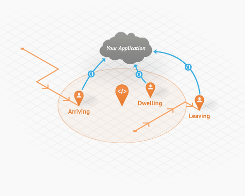
Battery-Managed Geofencing from Geoloqi

Hosted Spatial Storage:

Spatial storage allows you to create and store places, messages, and geofences. Create private places, quickly import datasets, search for nearby places and automatically sync relevant data to users. Geoloqi is optimized for use with real-time applications and battery-safe operations.
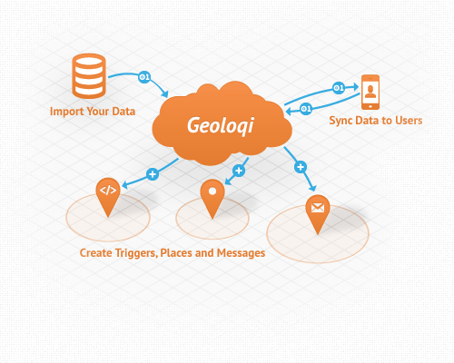
Location-Based Storage, Context, Points of Interest

Rich dwell-time and location-based analytics:

Geoloqi provides deep, real-time analytics on users and their location data and history and allows customers to create custom reports. It provides rich analytics and visualizations for tracking users, geofences and message conversions, place dwell time, visitor metrics, and more.
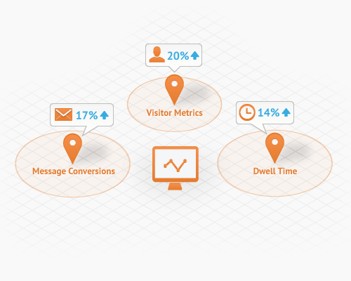
Location-Based Analytics for Mobile

Real-Time Location Tracking:

Geoloqi makes it simple to implement full-featured, real-time tracking in and out of doors, with minimal time and effort. Geoloqi offers SDKs for iOS, Android, Javascript, Ruby, PHP and more.
Real-Time Location-Based Tracking

Location-Based Messaging:

Push messages to end users upon arriving, dwelling or leaving a place, as well as based off of time or day or a user’s speed. Messaging works with any carrier and enables notifications for iOS and Android, SMS and Email for all devices.
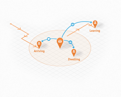
Location-Based Messaging for Mobile Devices

The Market to Date

To date, there has been an obvious disconnect between what developers, carriers and enterprise companies can offer business-to-business and business-to-consumer mobile products and services. Current location technologies have been pieced together by small vendors with limited functionality or built by in-house teams that do not have core location competency, making it challenging to develop reliable location-based applications and services. Very few companies have been able to take advantage of the possibilities that an advanced geolocation platform can offer. Today, Geoloqi can power truly mobile businesses, products and services with its next-generation location platform. Geoloqi solves all of the pending issues with first generation products like carrier dependence, privacy, development time, battery drain, and language silos.

Executive & Customer Quotes

“There’s no denying that we now live in an increasingly mobile world. Geolocation has the potential to become an indispensable part of our lives,” said Amber Case, CEO and founder of Geoloqi. “But in order for geolocation to be a valuable service to end users, the technology needs to be invisible yet opted into, private, and secure. There are incredible business opportunities and mobile advancements in markets like retail, security, healthcare, government, to a name a few. We’re inspired by the kinds of applications and services our customers are creating with Geoloqi and to be part of the tools that drive mobile innovation forward.”

“With Geoloqi, we’re able to track our personnel in real-time, anywhere in the world, on any device, ultimately saving lives in the process,” said David Ayres, of TATE, Inc. “For example, men and women working or traveling in high-risk areas will receive an emergency alert if they enter a dangerous area of a city or town. Geoloqi has taken safe geolocation to the next level.”

Going to SXSW Interactive?

SXSW Interactive 2012 - Amber Case KeynoteFounder and CEO Amber Case will be a keynote speaker at SXSW Interactive in March, where she’ll take the stage to discuss more implications of next generation geolocation, and have some exciting giveaways. To learn more about Geoloqi and unleash the power of location today, visit www.geoloqi.com.

About Geoloqi

Geoloqi is a powerful platform for real-time location based services, and makes it simple for enterprise partners, OEMs and mobile developers to quickly add rich geolocation functionality to apps and devices. It provides a complete, real-time toolkit for tracking, messaging, battery management, geofencing, storage and actionable analytics, with a language agnostic SDK and proprietary API. Founded in 2010, Geoloqi is based in Portland, OR and backed by Portland Seed Fund and TIE. For more information on Geoloqi, please visit www.geoloqi.com or follow @geoloqi on Twitter.

Media Contact
Vanessa Camones & Jennifer Lankford
theMIX agency for Geoloqi
[email protected]

Kyle Drake to Present “Building a Real-time geolocation game with Geoloqi using Node.JS” @ #NodePDX

Node PDX Conf, Portland, OR
Geoloqi Developer Kyle Drake will be presenting how he and the team at Geoloqi built a real-time geolocation game with Node.js and the Geoloqi API & Services. A quick description of Kyle’s presentation:
Kyle Drake of Geoloqi.com

There are very powerful things you can do with Node.JS, particularly with projects needing a lot of I/O operations. At Geoloqi, we have used Node.JS and Socket.IO to build a JavaScript client that allows our developers to map real-time tracking on a browser with almost no code needed. Our first project using this is MapAttack!, a truly real-time location-based geofencing game.

Hear about how we made the game, how we made it real-time, where we’re going, and where Node.JS is going to have a role in it. I will also cover what it took to build Geoloqi’s Real-time Streaming API, and how it can be used to bring real-time location functionality to existing applications.

I will also talk a little bit about the Reactor pattern, the mysterious thing underneath that powers Node.JS. I’ll discuss what Reactor patterns are good for (and not so good for), and compare them with threads. I will also compare Node.JS’s reactor pattern to ones in other languages.

Kyle Drake is a many-hats web developer and entrepreneur that speaks multiple languages, and has worked with numerous startups to build their infrastructure. As a software engineer for Geoloqi, he is helping to build their geolocation platform and real-time location-streaming API. He previously developed some of the top Facebook applications as a senior Facebook app developer for Dachis Group.

In his free time, Kyle likes writing more code, working on web site ideas, riding his bicycle around Portland, hiking in the mountains, skiing, reading anthropology and tech books, and he’s fairly good at playing the Star Trek pinball machine at Ground Kontrol.


Twitter: http://twitter.com/kyledrake
Geoloqi Developers Site: https://developers.geoloqi.com
Geoloqi’s Github: https://github.com/geoloqi
Kyle Drake’s Github: https://github.com/kyledrake

If you’d just like to come and check out Kyle’s Presentation and the other kick ass presentations lined up, get involved in some coding, hear what Node.js is all about, or just hang out please RSVP and get the event on your calendar!

If you’d like to be among the presenters, submit a proposal, and you too can step up into the coder spotlight.

Post credit: Thanks to Adron Hall for the original post and for the permission to repost it here! Original post on Composite Code.

Posted

Sat Nov 19 2011, 12:12pm

By caseorganic

Categories

Features

Tagged

Geoloqi – Now with GPX Export!

Geoloqi with GPX Export

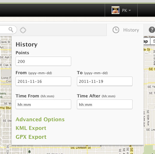
At the request of many, we’ve added GPX Export functionality to data in Geoloqi! Now you can export GPX data from the history tab on the map page in your Geoloqi account, as well as directly from the API.

What is GPX?

GPX (the GPS Exchange Format) is a light-weight XML data format for the interchange of GPS data (waypoints, routes, and tracks) between applications and Web services on the Internet. GPX has been the de-facto XML standard for lightweight interchange of GPS data since the initial GPX 1.0 release in 2002.

Downloading GPX from your profileGeoloqi with KML and GPX Export
Simply log into Geoloqi and click on the History tab.

You’ll see two options: Download KML and Download GPX.

Downloading GPX data from the Geoloqi API
Add location/history.gpx to the end of the call to download GPX.

You can see more history options in the Geoloqi API Documentation.

Bring Wikipedia to Life with Geoloqi! Real-time Content Based on Your Location

Location-based Wikipedia Articles in Geoloqi!Geoloqi - Location-Based Content from WikipediaUpdate: Thanks to Marshall Kirkpatrick from ReadWriteWeb for writing an article on this topic this morning! New Wikipedia Layer on Geoloqi Gives You Vision Beyond the Greek Gods.

Have you ever walked down the street in a new city and wanted to know what was around you? And I don’t mean bars and restaurants and coffeeshops, but the old buildings, strange statues and curious parks. There is a whole bunch of data out there that’s not tied to place, and a great deal of it exists on Wikipedia.

Back when we were working on Geoloqi at a dining table at a tiny apartment, ReadWriteWeb’s Marshall Kirkpatrick checked out what we were doing and got very excited. “I want to be able to get push notifications on my phone every time I pass near an off-line place that has a Wikipedia entry written about it”, he wrote. We thought it was a good idea too.

There are many apps out there that have location-based Wikipedia data, some examples are Wikineer (built on Yahoo’s FireEagle), Geopedia and an iOS app from SimpleGeo. The problem with each of these apps is that you can only see the location-based content on a map, and you have to have the app open to see the information. You can’t just walk around and get interesting information pushed to you. On other apps you have to query to see what’s around you.

Getting the Dataset

Pushing location-based data to phones comes with a few problems. The first one is getting a good geocoded Wikipedia dataset. While we were searching for one, we encountered a few from developers who tried to make location-based geoplayers in the past. The datasets weren’t really ready for prime-time, though, so we looked around for a better source.

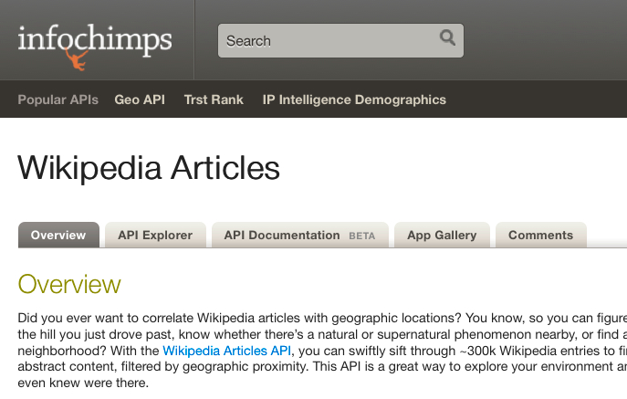
Then at the Where 2.0 Conference we talked to our friends at InfoChimps, an awesome company that provides big datasets for developers like us. They agreed that a formatted set of geocoded Wikipedia articles would be a great dataset to bring to life. A few months later, InfoChimps’ Dennis Yang published a set of geocoded Wikipedia articles! and sent us an E-mail about it. We were able to take the articles and put them into a Layer in Geoloqi. After some testing and debugging, we were ready to release it life to the world.

Geocoded Wikipedia Articles from Infochimps

Subscribing to the World

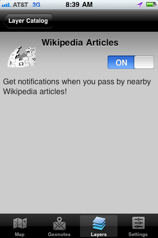
Turn on Wikipedia Articles Layer in GeoloqiYesterday when I was heading into the office, I passed a curious building that I wanted to know more about, so I turned on the Geoloqi Wikipedia layer.
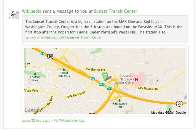
Seconds later, I received a push notification about that exact building! It turns out that it was called the Weatherly Building, and it was built by an ice cream tycoon who was credited with inventing the ice cream cone. It turns out that Mr. Weatherly served 90% of the regions ice cream business at the height of his success in the 1920′s, and operated out of a second hand freezer in a small candy shop when he started in the 1890s. I will never look at that building in the same way again.

To subscribe, simply download Geoloqi for iPhone or Android and click on the Layers tab. You’ll be able to see a list of available content around you. Simply click on the Wikipedia layer and turn the switch to “on” to turn it on. You’ll start getting Geocoded Wikipedia articles as you move around! If you already have Geoloqi, you can subscribe simply by clicking the button below. You’ll be prompted to log into Geoloqi and the Wikipedia layer will be added to your account.

Subscribe to Wikipedia on Geoloqi!

Try It Out!

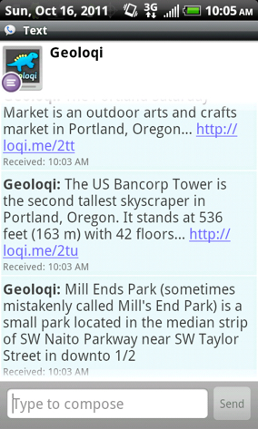
We made the Wikipedia article layer available worldwide, so if you’re anywhere in the world that has geocoded Wikipedia articles, you’ll be able to turn on the Geoloqi layer and get real-time information! Also, all of the Wikipedia articles you pick up will be pushed to your activity stream, so you can read them later.

Geoloqi Activity Stream - Wikipedia Articles

Next Steps

Geoloqi’s apps for iPhone and Android, while functional, drain the phone’s battery. We’ve been working on battery safe GPS technology for the past few months and persistent GPS functionality will be possible when we’re finished, or at least more feasible. We’ll release the battery-safe features into the Geoloqi API and libraries so that you can use them too.

We’ll be adding more layers soon, and are going to make it increasingly easy for everyone to add layers to Geoloqi. We’ll post more information here on the blog. And if you have feedback on the layer, please let us know! We’re excited to hear about it.

Geoloqi is a platform for real-time geo-content that is language agnostic, device agnostic, and driven by a real-time developer toolkit. You can follow us on Twitter @geoloqi, or you could try following the International Space Station instead. A great big thanks to the Geoloqi team, Marshall Kirkpatrick and InfoChimps for all of their help, data, and ideas!

Geoloqi Developer Kyle Drake to speak on building real-time games at Keeping it Realtime Conference in Portland, Oregon!

We’re happy to announce that on November 7th 2011, Geoloqi’s Kyle Drake will be speaking at the Keeping it Realtime Conference in Portland, Oregon!

Who is Kyle Drake?
Kyle Drake is a software engineer at Geoloqi. Drake helped build Geoloqi’s real-time location-streaming API, and he developed the Sinatra Synchrony framework for Ruby specifically for MapAttack, a real-time location-based urban geofencing game built on the Geoloqi platform.

He also developed some of the top Facebook applications as a senior Facebook app developer at Dachis Group in Portland, Oregon.

Session Description: Building MapAttack: A Realtime Geofence Game

Drake will talk about what was involved in building MapAttack, a truly real-time location-based geofencing game. Challenges and limitations, advantages and disadvantages will be discussed.

He’ll also discuss the technology behind MapAttack, including Sinatra Synchrony for Ruby, which he built specifically for the Geoloqi’s geofencing game MapAttack. He’ll also cover what it took to build Geoloqi’s real-time streaming API and how it can be used to bring real-time location functionality to existing applications.

What is KRT Conf?

Keeping is Realtime is a conference by developers, for developers with passionate, kickass speakers.
It’s a place where brand new frameworks are unveiled, there’s education for beginners and veterans. It’s a place for diverse perspectives and stacks in a venue structured to maximize discussion. This makes for a series of awesome networking events over the course of two amazing days.

When?

Nov. 7th-8th, 2011 at the Left Bank Annex building in Portland, OR.

Tickets!

Get tickets for Keeping It Realtime

More about MapAttack!

MapAttack is a real-time location-based game built on the Geoloqi platform. You can follow MapAttack! on Twitter at @playmapattack. You can download the MapAttack source code here.